GIS Full Form
GIS Full Form
GIS stands for Geographic Information System. It is a system of hardware and software that gives display, capture, management of geographic information. The information is basically data that specify the exact location or description of geographic features that may be man made, natural or spatial data. Moreover it is a visual element and features on a map that provides, to locate, display, analyze and model information. The data for the information can be gathered from on-site surveys as well as from remote sensing, photogrammetry or GPS techniques.
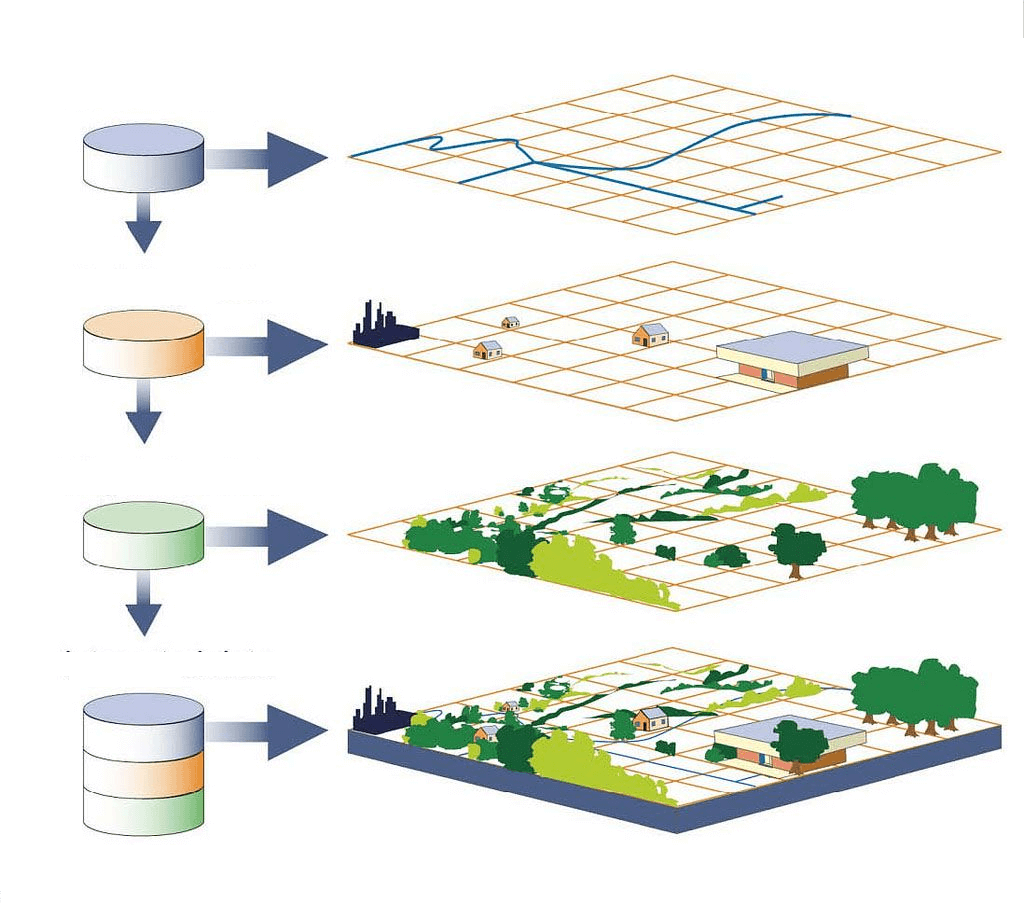
On the basis of that primary data collection the layout of the map is drawn, which is an illustration of the earth in 3d and high resolution configuration. So, basically GIS is a combined layer of information about a place through which we can get a better understanding of that place. Further, GIS links maps to databases and creates a visualization of data that makes interactivity between the map and the data in the database. In another word GIS is a computer based system used in input, output, storage, manipulation, retrieval and analysis of spatial data.
If we see its development, the words “Geographic Information System” was given by Roger Tomlinson in 1963, with the publication of “A Geographic Information System for Regional Planning”. He is called the Father of GIS as he created the first computerized GIS on the Canada Geographic Information System in 1963. The first example of spatial analysis was used in the field of epidemiology in Paris in 1832. It was Charles Picquet, a French geographer and cartographer, who created a map outlining the forty- eight districts in Paris. He used halftone color gradients, to give a visual representation for the number of deaths due to cholera, per every 1,000 inhabitants.
Further, John Snow, an epidemiologist and physician determined the source of a cholera outbreak in London through spatial analysis in 1854. It was one of the earliest successful uses of geographic methodology to point out that the water sources within the cluster were responsible for the outbreak of the epidemic. In the early 20th century through the development of photozincography, we got maps splitted into layers, like; one layer for water and another for vegetation. Later, this map splitted into layers became one of the main features of a contemporary GIS. But since the photographic maps were just an image with no database to link to them, it cannot be considered a GIS in itself.
Further, the world’s first true operational GIS was developed in Canada, in 1960 by Roger Tomlinson. It was called the Canada Geographic Information system (CGIS). It was used to store, analyze and manipulate data collected for the Canada Land Inventory. In the 1990s CGIS was used to build a large resource database in Canada. But it was never available commercially. Moreover, Howard T. Fisher in 1964 formed the laboratory for computer graphics and spatial analysis at the Harvard Graduate School of Design(LCGSA 1965-1991), which developed and distributed the seminal software code and system, like; SYMAP, GRID, and ODYSSEY, which were the sources for commercial development- in Universities, Research Centers and Corporations Worldwide.
Further, many commercial vendors of GIS software have emerged like; M&S computing along with Bentley Systems incorporated for CAD platform, Environmental Systems Research Institute (ESRI), MapInfo Corporation , Earth Resource Data Analysis System(ERDAS) etc. The first desktop GIC product, Mapping Display and Analysis System (MIDAS) was released for the DOS operating system in 1986. It was renamed to MapInfo for windows in1990, when it was ported to the Microsoft windows platform. It is from here, GIS started moving from the research department to business environment. Finally by the end of the 20th century, due to growth in various system users were starting to explore viewing GIS data over the internet. Geospatial data and mapping applications are being made available via the World Wide Web.
Now, the functions of GIS are: data entry, data display, data management, information retrieval and analysis. It can be used by a scientist, researcher, engineers, transport, insurance, telecommunications, resource management and by the development planning people. It can be also used for retail businesses in order to help them to determine where to locate a new store.
The advantages of GIS is that people can see the world in a different way by mapping the position and quantity of things through GIS. People can know the density of people and objects as well as the changes that occur. It also gives information about the happening inside a specific area or nearby to a specific area.
Overall, if someone wants to make his career in GIS, then it is a very bright area, as it will be in demand for a long time. However, like other careers, GIS is also changing very fast with new techniques every day. If we talk about the growth in this area, then the salary depends upon one’s work experience as well as varies according to the job location and title.